This seven and a half mile route links Dronfield and Chesterfield parish churches. It follows the River Drone valley and then climbs over the hills to join the Chesterfield Canal along the Rother valley and leads into the town centre. The distinctive blue way markers will guide you along the field paths, lanes, towpaths and roads that comprise this varied walk.
Regular bus services link Chestefield and Dronfield and the route crosses bus routes at Unstone and Old Whittington giving the option of returning to the start point after completing a shortened section of the walk. For information on bus and train times visit the County Council’s website. Car parking is available below the Dronfield Sports Centre, where there are also toilets.
The information provided here is subject to change and the authors can accept no responsibility for such. You are advised to refer to the Ordnance Survey Explorer map 269 Chesterfield and Alfreton, for detailed 1:25,000 mapping showing public rights of way along the route.
The leaflet on which this walk description is based was produced with support from the Derbyshire Community Foundation, Dronfield Town Council and Derbyshire County Council, Three Valleys Project.
The society does not accept any liability as to the safety or the suitability of the walk. Individuals should take whatever action is necessary to ensure their own safety.
Walk Instructions
1. Begin by the Sports Centre bus stop in Dronfield Civic Centre. Take the only traffic access road out of the centre. Turn right at the Peel Monument and go down to Dronfield Parish Church (open most days). Then walk down Church Street to the T-junction with Lea Road. Turn right and follow Lea Road until you reach the back of the White Swan public house where you turn left along a narrow roadway to join the main road through the town centre.
Pass under the railway bridge and cross the road at the zebra crossing. Continue for a short distance and then take the next right to walk along Mill Lane. Follow Mill Lane as far as the signed way to the left along a fenced path through the industrial estate. Turn right along Callywhite Lane and follow to a roundabout at the far end. Follow the signed public footpath (access path to Dronfield 2000 Rotary Walk – also a route signed as Frith Wood, Summerly & Unstone Walk).
2. Pass through the woods downhill to the River Drone to reach Halfacre Lane. Cross over and continue ahead to reach the boardwalk path over a boggy section. Pass through a cluster of houses to reach Unstone. Turn left at the far end of the industrial building and take the path to the right of the gate uphill to join the “Unstone Line”. Turn right to follow this old railway track.
Keep to the edge of the sports field until a gate is reached; do not pass through, but head diagonally right across the field to enter the woods. Go down the steps by the stream and cross over the minor road. Turn left to join the Chesterfield Round Walk route and proceed up the drive which forks right in a few metres. Follow the drive and fork right at Siscar House to walk along the long drive towards Ramshaw Lodge
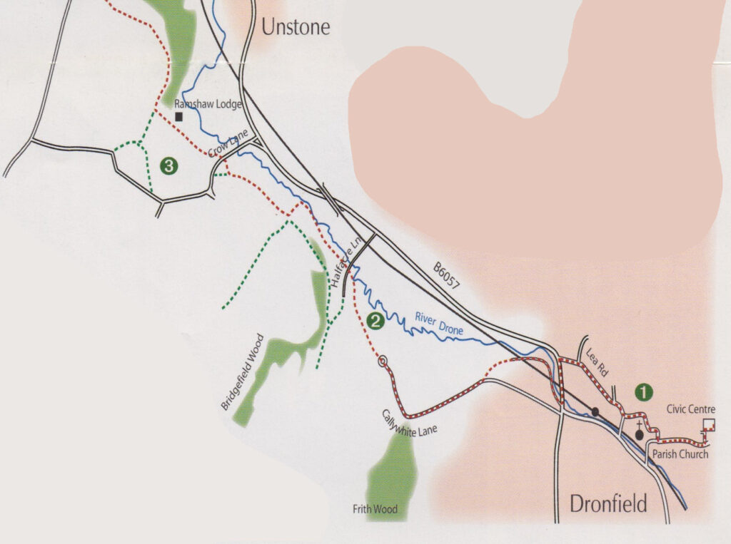
3. Just before the drive enters the woods follow the path to the left of the white gate up through the wood. Cross the stream and pass through a metal kissing gate then head for a gap in the bank ahead. At the second metal kissing gate turn right along an enclosed track. At the path junction bear left uphill through the woods.
Keep left at a metal gate and continue uphill into a large open field. The path now crosses this field and follows the left-hand hedgerow uphill all the way to a minor road just above the T.V. transmitting mast.
4. Turn right along Windmill Lane and after 50m turn left to follow a path through the right hand field entrance. Keep to the left of this field, ignoring minor paths to the right. At the top corner of this field take the path through bushes to walk along Grasscroft Wood boundary. In 200m emerge into open fields and keep along track close to the woods. In the second field turn right at a crossing of paths to go straight through the wood.
In a short distance emerge from the woods by a seat where you can admire the view of Chesterfield and on a good day can see Bolsover Castle in the distance to your left.
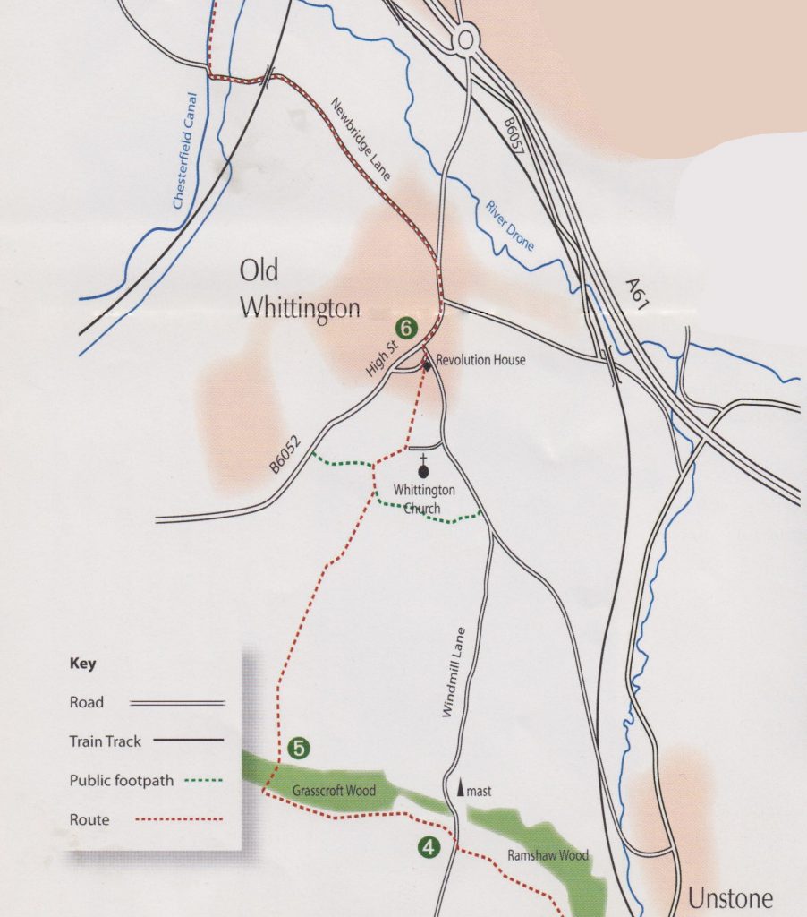
5. Head straight across the large field aiming just to the left of the crooked spire in the distance. Cross the stile with 3 stone steps and then keep to the left edge of the next three fields. By a high wooden fence continue down to cross a stream over a stone footbridge. Go up hill on the left-hand path for a short distance and then climb the 14 steps up to the graveyard. The path now follows the stone wall between the graveyards and alongside the churchyard. Do not enter the church at the gate, but turn left along a narrow footpath to reach a minor road.
Cross over and continue down path to reach the High Street by number 7. Turn right along this road passing by the Revolution House and the “Cock and Magpie.” Cross Church Street North and continue along the main road. Just beyond Howard Drive cross over the busy main road with care at the pelican crossing. Continue past the “Bulls Head” down Whittington Hil and then left along Newbridge Lane.
6. Keep straight ahead along this road for 3/4 mile as it changes from a residential street into a quiet country lane. Pass under a rail bridge and over the river bridge to eventually reach Chesterfield Canal at Wheeldon Mill Lock. Turn right and follow the canal towpath for 3/4 mile to reach Tapton Lock visitor centre. Continue along the towpath under the main road tunnel. At Tapton Mill Bridge cross to the other side of the canal. Ignore signs to the station and keep by the waterside as you pass the junction of the canal and the River Rother.
Follow the river upstream. After passing under two bridges re-cross the river, turn immediately left alongside the right-hand bank to reach a minor road in a short distance. Continue along this road to reach a main road. Turn left to cross the river, cross the road and take the service road behind houses to reach a bridge to once again re-cross the river. Turn right leaving the waterside and go up the road to pass the station entrance.
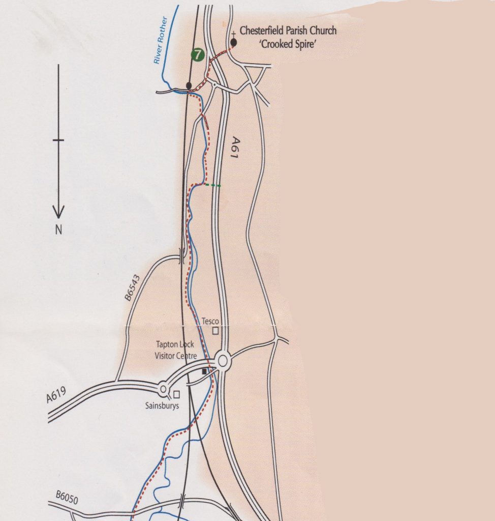
7. Cross over the main road with care and continue uphill to pass the “Chesterfield Hotel”. Take the footbridge just beyond the entrance to cross over the by-pass and into Corporation Street. Keep to the right hand road and walk uphill passing the Pomegranate Theatre and the Chesterfield Museum. Cross the main road by the zebra crossing and enter Churchyard where the walk finishes. The Tourist Information Centre is to be found in the square beyond the church.